No products
Product successfully added to your shopping cart
There are 0 items in your cart. There is 1 item in your cart.


Garmin eTrex® 30x Hiking GPS
G020001
Garmin eTrex® 30x hiking GPS + preloaded Garmin TopoActive Western Europe map
Obsolete GPS from 2010, you can opt for the eTrex 32x GPS by clicking on this link
Portable GPS intended for hiking and outdoor activities: cycling, mountaineering, navigation (fishing), treasure hunt
The eTrex® 30x retains all the features that made eTrex® so successful.
A new high-resolution 2.2-inch, sunlight-readable display has been added.
The internal memory has been expanded (3.7 GB) and the Garmin TopoActive map of Western Europe is preloaded.
• New 2.2-inch 65,000 color sunlight-readable display
• 240x320 pixel resolution
• Preloaded Garmin TopoActive Western Europe map with shaded relief
• Worldwide basemap with shaded relief
• 4GB internal memory and possibility to add a microSD™ memory card
• Useful information for hiking and cycling
• Ability to create routes
• High-sensitivity WAAS-enabled GPS receiver with HotFix® and GLONASS support
• Maintain GPS position even in wooded areas
• 3-axis tilt-compensated electronic compass
• Barometric altimeter
• Wireless Features
• Resistant for outdoor activities (IPX7)
• High autonomy, up to 25 hours
IGN Topo France, DOM-TOM, Mountain and European country maps available as an option
GPS Garmin USA

42 Items
In stock
- Remove this product from my favorite's list.
- Add this product to my list of favorites.
Data sheet
| Weight | 141.7g (including batteries) |
| Dimension | 5,4 x 10,3 x 3,3 cm |
| Screen | 3.5 x 4.4 cm (5.6 cm diagonal or 2.2 inches) / transflective TFT color screen, 65,000 colors |
| Resolution | 240 x 320 pixels |
| Certificate | IPX7 |
| Instruments | high sensitivity receiver, barometric altimeter, electronic compass |
| Battery | 2 AA batteries (not included): NiMH or Lithium recommended |
| Autonomy | up to 25 hours |
| Internal flash memory | 3.7 GB (preloaded maps) |
| MicroSD card reader | Yes |
| Connection PC | USB |
| Preloaded maps | Garmin TopoActive Western Europe |
| Waypoints | 2000 |
| Routes | 200 |
| Tracking log | 10,000 points / 200 saved tracks |
| Manufacturer reference | 010-01508-14 |
More info
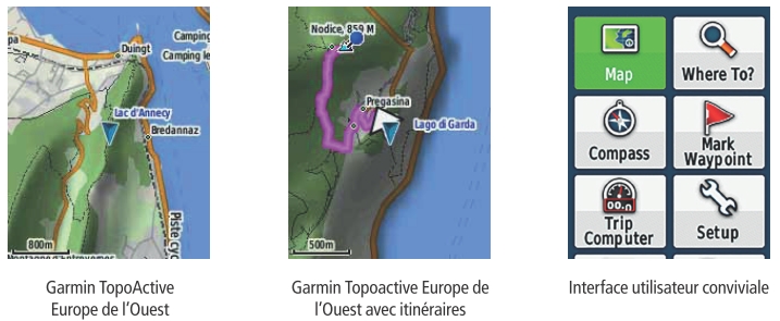
SCREEN
The eTrex® 30x is equipped with a 2.2 inch 65,000 color screen, readable in direct sunlight with a very good resolution (240x320 pixels). The screen has anti-glare technology.
MAP
This new version of the eTrex® integrates the Garmin TopoACtive map of Western Europe as well as a worldwide basemap with shaded relief.
The Garmin map is preloaded with all the necessary information for outdoor activities (hiking, cycling...).
Mapping provides the ability to create routes and display elevation changes.
TopoActive Western Europe map coverage: 23 countries
Albania, Andorra, Austria, Belgium, Denmark, Finland, France, Germany, Iceland, Ireland, Italy, Liechtenstein, Luxembourg, Malta, Monaco, Netherlands, Norway, Portugal, San Marino, Spain, Sweden, Switzerland, United United and the Vaticans
A microSD™ card can be added to load additional maps:
- Topo maps
- BlueChart® g2 nautical charts
- City Navigator® NT maps
- BirdsEye Satellite Imagery (by subscription)
GPS MEMORY
Internal memory has been increased to 3.7 GB and a microSD™ card slot allows additional maps to be loaded (optional).
POWERFUL GPS RECEIVER
Equipped with a high-sensitivity WAAS-enabled GPS receiver and the HotFix® satellite forecasting system, the eTrex® 30x quickly and accurately calculates your position and maintains its GPS position even in densely wooded areas and deep valleys.
INTEGRATED SENSORS
The eTrex® 30x incorporates a 3-axis tilt-compensated electronic compass and barometric altimeter that tracks changes in atmospheric pressure to detect accurate elevation. With these sensors, you have the ability to graphically represent barometric pressure over time.
WIRELESS FEATURES
The eTrex® 30x offers the possibility of transferring its information wirelessly. Share waypoints, tracks, routes and geocaches wirelessly with other compatible devices by simply pressing "send".
It is also possible to connect wirelessly to compatible Garmin devices, such as VIRB™ cameras and auxiliary sensors, such as Tempe™ sensors, accelerometer and heart rate monitor.
GPS RESISTANT
The eTrex® 30x has been designed to withstand the climatic conditions encountered during outdoor activities.
The ergonomically designed GPS is solid and resistant to dust and water (waterproof class IPX7).
SUPPORT
The GPS is compatible with a wide range of carriers for all your activities: portable mode, all-terrain vehicle, bicycle, boat, car
PAPERLESS GEOCACHING
With the eTrex® 30x, there is no need to manually enter coordinates, the GPS supports geocaching GPX (treasure hunt) files to download geocaches and detailed data.
AUTONOMY
The GPS uses 2 AA batteries (not included) allowing up to 25 hours of use.
Included in this pack:
• Garmin TopoActive map of Western Europe (preloaded)
• Worldwide basemap with shaded relief
• USB cable
• Documentation
Reviews
présidente club rando
achat satisfaisant
Bon outil pour une initiation à la rando avec GPS
Accessories
Garmin watch/GPS ...
25,00 €Garmin GPS car kit
49,99 €Carabiner with Ga...
19,99 €Holder with Garmi...
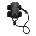
9,99 €Garmin GPS backpa...
19,99 €Garmin GPS neck s...
24,99 €Garmin GPS outdoo...
19,99 €Garmin GPS bike m...
11,99 €Garmin GPS Marine...
29,99 €Support automobil...
38,99 €Garmin GPS carryi...
19,39 €Garmin GPS hard case
49,99 €Protective cover ...
19,99 €IGN Topo France v...
134,99 €Map IGN Topo Fran...
269,99 €IGN Topo France v...
179,99 €IGN Topo Pro maps...
123,49 €Topo Maps Regions...
152,00 €Garmin City Navig...
80,99 €Garmin GPS cord
12,99 €Mains charger + G...
29,99 €Garmin GPS suctio...
75,99 €