No products
Product successfully added to your shopping cart
There are 0 items in your cart. There is 1 item in your cart.


GPSMAP H1 / GPSMAP H1i Plus Garmin
GPS de randonnée GPSMAP H1 / GPSMAP H1i Plus Garmin
Model to choose:
- GPSMAP H1: GPS with color touch screen and speaker
- GPSMAP H1i Plus: GPS with color touchscreen, speaker, microphone (voice control), integrated cameras, inReach® Plus technology (satellite communication via the Iridium global network) and SOS message sending to the professional Garmin Response response center (available 24/7)
Option cartographie (carte microSD/SD):
- IGN TOPO FRANCE V7 PRO FRANCE AULS +DOM-TOM
-IGN TOPO FRANCE V7 Pro Region
The Garmin GPSMAP H1 and GPSMAP H1i Plus are portable, rugged hiking GPS units based on a modern hybrid design and equipped with the best Garmin technologies available today.
They feature a super-bright 3.5-inch color touchscreen and physical buttons for added flexibility.
Interactions with the device are natural and text entry is fast.
The intuitive interface focuses on mapping and navigation.
Easily navigate trails with preloaded TopoActive maps, downloadable satellite imagery, and the Outdoor Maps+ subscription option for always-on access to premium maps.
The GPSMAP H1i Plus model features inReach Plus technology.
With an active inReach satellite subscription, share your adventures with your loved ones, even outside the mobile coverage area.
Text, share your location, or use the built-in camera and microphone to take and share photos and voice messages in real time.
• Dimensions: 6,7 cm x 17,9 cm x 3,3 cm (2,6″ x 7″ x 1,3″)
• TFT transflective color touchscreen
• Chemically strengthened glass
• Format d'affichage: 4,7 x 7,7 cm (1,9″ L x 3″ H) / 8,9 cm (3,5″ de diagonale)
• Screen resolution: 282 x 470 pixels
• Long autonomy of 145 hours (6 days) in intensive mode with a high capacity 4400 mAh battery
• Multi-GNSS and Multi-band GPS technology for even more precise geolocation in harsh environments
• MIL-STD-810 certified for shock and temperature resistance (-20°C to +60°C)
• Water resistant interface (IP67)
• inReach technology to stay in touch with your loved ones, base camp when the network is non-existent [GPSMAP H1i Plus]
• 3-axis tilt-compensated electronic compass
• Barometric altimeter
• Creation of unlimited routes and activities, waypoints
• Loop route calculation
• Map Compatibility: City Navigator, Topographic Maps, BlueChart G2 Marine Charts, Custom Maps
• LiveTrack real-time tracking functionality
• TracBack function to return to the starting point
• Weather Garmin
• Equipped with an LED flashlight, an SOS (morse code) beacon to signal its position and a siren
• Dual microphones for recording voice messages and giving voice commands [GPSMAP H1i Plus]
• Quality speaker for audio playback [GPSMAP H1i Plus]
• Wireless features: Wi-Fi, Bluetooth, ANT+
• Interface: USB-C
Cartography and memory:
• Preloaded TopoActive maps for Europe, the Middle East and Africa, plus easy-to-access global maps
• Internal memory: 64 GB
• MicroSD card slot of 1 TB max (possibility of adding topographical maps)
• Detailed hydrographic characteristics (coastal lines, shores of lakes and rivers, swamps and seasonal and permanent watercourses)
• Points of interest with search function (parks, campgrounds, viewpoints and picnic areas)
• Shows state, federal, and local parks, forests, and nature parks
• Automatic route definition (turn-by-turn route function)
• Map segments: 15,000
Nouveaux accessoires de fixation avec un support en forme de Ɪ (disponibles en option en bas de page)
Ideal for hiking, mountaineering, high mountains, treks, travel and expeditions
GPS for communities, workers and forestry operators
- delimitation of forests and plots,
- studies of topographic, hydrographic data, and identification of cutting areas
Possibility to pay in 3 instalments, ask us at contact@mgaffaires.com
GPS Garmin USA

5995 Items
In stock
- Write a review
- Remove this product from my favorite's list.
- Add this product to my list of favorites.
More info
New features and technologies:
COLOR TOUCH SCREEN
The bright, sunlight-readable 3.5-inch color touchscreen features chemically strengthened glass to resist scratches.
Easy to use and read, it is compatible with gloves. Just tap, zoom and swipe on the maps to follow your route.
ROBUST AND MODERN HYBRID DESIGN
Designed specifically for the most demanding environments, the GPSMAP H1/H1i Plus are resistant to bad weather and extreme temperatures.
They have been rigorously tested to meet MIL-STD 810 for thermal, shock, water (IPX7) and vibration resistance.
Their all-new hybrid design incorporates a durable touchscreen and intuitive push buttons for greater versatility, even with gloves, whatever the conditions. The quick action button allows users to customize the device's functions to their specific needs.
INTEGRATED CAMERAS (H1i PLUS model)
The built-in front and rear cameras allow you to take selfies and photos of your trip.
With an active inReach subscription, share your photos of your outings in real time, even without a mobile network.
VOICE CONTROL (H1i PLUS model)
Use voice commands to easily manage many tasks, like recording, tracking, taking a photo and more:
Available in English, German, Italian, Spanish, French, Swedish, Danish and Dutch.
PHOTOS AND VOICE/TEXT MESSAGING (H1i PLUS model)
Send a selfie or share a sunset. Tell your loved ones how much you miss them with a 30-second voice message or send longer bulk text messages (up to 1,600 characters).
No mobile coverage required. An active inReach ® satellite subscription is required.
FLASHLIGHT AND SIREN
Use the built-in LED flashlight as a beacon light or to light your way in the dark.
A powerful built-in siren can attract attention when needed and may be more than useful in an emergency
OUTDOOR MAPS+
Subscribe to an Outdoor Maps+ subscription to access a variety of premium map content around the world.
Content is updated regularly and sent to your device via Wi-Fi.
Principales fonctions :
ADVANCED NAVIGATION
Navigate with preloaded TopoActive maps for Europe, the Middle East and Africa, as well as easy-to-access global maps.
View contour lines, elevations, geographic points and more.
INTERACTIVE SOS (H1i PLUS model)
Explore with peace of mind: You can send an interactive SOS message with your GPS coordinates to the Garmin Response Center, our 24/7 global coordination center to help you in an emergency (an inReach satellite subscription required).
SATELLITE IMAGERY
Download high-resolution photorealistic maps directly to your device via Wi-Fi® technology.
Find trails, choose camp and parking locations, create waypoints and much more.
GLOBAL IRIDIUM SATELLITES NETWORK (H1i PLUS model)
Instead of relying on antenna-based mobile coverage, your SOS messages and alerts are sent via the 100% global Iridium satellite network.
LOCATION ACCURACY
Benefit from multi-band GPS and multi-GNSS support for superior positioning accuracy.
AUTONOMY
Long battery life allows up to 145 hours in GPS mode with all satellite systems + multi-band mode (assuming typical use with SatIQ technology).
ON THE MOVE
Both GPS, GPSMAP H1 and GPSMAP H1i PLUS feature Groove Mount 2 (next generation) and include a removable loop with carabiner for added versatility during your adventures.
They are also compatible with other accessories, available as an option (groove support 2, etc.).
GARMIN WEATHER
Receive real-time weather forecasts to be informed of changing weather conditions. This feature requires an active Wi-Fi or mobile connection and use of a companion Garmin app on your compatible smartphone.
With an active inReach satellite subscription and the GPSMAP H1i Plus model, you can also travel beyond mobile coverage and access satellite weather updates for your current location, destination and more.
ABC SENSORS
Benefit from a built-in altimeter for altitude data, a barometer to monitor the weather and a 3-axis electronic compass to orient yourself.
PLAN YOUR ADVENTURES
Easily plan your trips by easily locating geographic points, sharing your route and much more.
An active Wi-Fi connection is required, or a mobile connection with the Garmin Explore app on your compatible smartphone is required.
GARMIN SHARE
Easily share saved locations and routes with your friends' compatible Garmin devices.
CLIMB PLANNER
Check out the upcoming climbs on your route, when they will occur and how steep they will be.
Applications:
GARMIN EXPLORE™ APP
Synchronize and share your hikes from anywhere!
This all-in-one app is designed for off-grid adventurers and outdoor enthusiasts. Download it to your smartphone to plan, navigate and review your activity.
GARMIN MESSENGER™ APP
Never lose touch with your loved ones and friends.
Download the Garmin Messenger app to your smartphone, then pair it with your inReach® device for quick and easy messaging that's not limited to cell phone coverage areas.
APPLIED BALLISTICS® QUANTUM APP
Use your compatible Garmin device with the Applied Ballistics® Quantum app (unlock fee required) to access sighting solutions for long-range shooting.
OUTDOOR MAPS+
With a paid subscription to Outdoor Maps+, you get always-on access to a wide variety of additional premium maps from around the world, regularly updated and streamed directly to your compatible Garmin device via Wi-Fi®.
Subscriptions are €5.99 per month or €59.99 per year.
INREACH® SUBSCRIPTION PACKAGES
Activate your inReach subscription to stay in touch with your loved ones beyond the limits of mobile networks. Subscriptions enable global two-way messaging via the 100% global Iridium ® satellite network.
In the event of an emergency, you can send an interactive SOS message with your GPS coordinates to the Garmin Response SM global response coordination center, available 24/7.
Includedin the package:
- GPSMAP H1 / GPSMAP H1i Plus (version of your choice)
- Preloaded Topoactive maps
- Access to BirdsEye satellite images (download directly to device without subscription)
- USB-C Charging/Data Cable
- Buckle carabiner
- Documentation
Manufacturer references:
- GPSMAP H1: 010-02920-01
- GPSMAP H1i Plus: 010-02921-01
Comparison of Garmin GPSMAPs: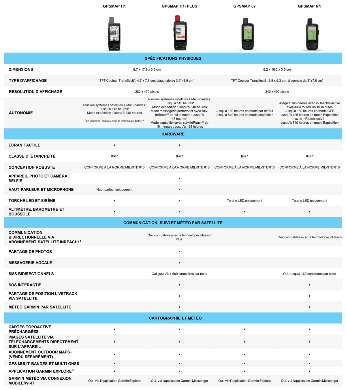
Reviews
Accessories
Garmin GPS neck s...
24,99 €Garmin speed/cade...
62,99 €Garmin GPS cord
12,99 €Garmin GPS Floati...
7,99 €Garmin inReach Mi...
14,99 €Garmin USB Type A...
14,99 €Garmin USB Type C...
14,99 €Garmin HRM-Fit He...
143,99 €HRM 200 Garmin ca...
76,49 €HRM 600 Garmin ca...
144,49 €Ign topo france v...
134,99 €Garmin GPSMAP H1 ...
28,49 €GPSMAP H1 Garmin ...
14,99 €GPSMAP H1 Garmin ...
14,99 €