No products
Product successfully added to your shopping cart
There are 0 items in your cart. There is 1 item in your cart.


GPS Cross Plus TwoNav
GPS CrossMore TwoNav
GPS dedicated to hiking, mountain biking, cyclo-cross and adventure sports
Model to choose:
- Cross more - blue (32 GB)
- Cross more - blue (64 GB)
IGN cartography of your choice (in addition to the Topo France 1:100000 map)
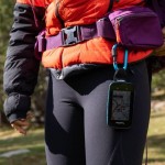
The Cross Plus Twonav is an extremely light, compact and resistant navigation device, equipped with a high quality touch screen.
Ideal for mountain activities, cycling and hiking, benefit from all the latest Twonav technologies to make the most of your outings.
New in GPS Cross Plus:
• 4 navigation networks (GPS+Galileo+Glonass+Beidou) with the new, more powerful UBlox GPS chip, geolocation is faster
• New SBAS EGNOS satellite augmentation system for wider coverage and higher accuracy
• Multi-band Wi-Fi technology (2.4 Ghz / 5 Ghz) for fast file transfers
• Dual Bluetooth for simultaneous use of sensors and smartphone connection
• Tom-Tom France map in addition to OSM Europe
Technical specifications:
• Size: 110 x 63 x 21 mm - Weight: 172 g (battery included)
• 3.2" Blanview screen with Optical Bonding (sunlight readable)
• Resolution 480 x 800 pixels
• Screen protected by Gorilla Glass and capacitive multitouch (use even with gloves)
• Easy to use with 4 front and 2 side buttons
• Military certification MIL-STD-810 (resistant to shocks, rain and extreme temperatures)
• Topographic map and OpenStreetMap world map (OSM)
• 32 GB internal memory: 28 GB of space for data (add your own maps)
• 120 customizable data fields
• digital compass
• Altimetric barometer
• Connexion PC : USB-C (Mass storage / OTG)
• Built-in 3300mAh battery
• Buzzer and tricolor LED
• Connected GPS: Dual BLE sensors, Wi-Fi (2.4 Ghz / 5 Ghz)
• Autonomy: 20 hours
• Robust, resistant to shocks, water, dust and mud: IP67
• Supported temperatures: -10°C ~ 50°C
Nombreux supports disponibles: supports vélo (potence, guidon, frontal), housse de transport, lanières, attache sac à dos
Wireless software and feature updates over Wi-Fi
IGN cartography of your choice: whole France or 10 departments, Spain, Germany, Switzerland, Italy, aeronautical France, Great Britain, Austria
Land 10 software license (tool to plan your routes, analyze your data ...)
Possibility to pay in 3 instalments, ask us at contact@mgaffaires.com

35976 Items
In stock
- Remove this product from my favorite's list.
- Add this product to my list of favorites.
Data sheet
| Weight | 172g (with battery) |
| Dimension | 110 x 63 x 11 mm |
| Screen | Blanview (3.2”) |
| Resolution | 480 x 800 pixels |
| Certificate | IP67 |
| GPS chip | GPS + Galileo + Glonass + Beidou |
| Battery | Li-Ion 3300 mAh |
| Autonomy | 20h |
| Internal flash memory | 32 GB of which 28 GB available for data |
| Connection PC | USB type C |
| Manufacturer reference | V1082B |
More info
The key points of the GPS:
• A COMPACT GPS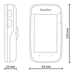
• TECHNOLOGY
GPS Cross Plus incorporates more powerful chips with multi-band Wi-Fi (2.4Ghz / 5Ghz) for fast file transfers.
The 4 navigation networks (GPS + Galileo + Glonass + Beidou) allow fast and precise positioning.
The SBAS/EGNOS (European Geostationary Navigation Overlay Service) satellite augmentation system allows for wider coverage and greater accuracy in geolocation.
Connect sensors like a heart rate monitor and receive notifications simultaneously with Bluetooth Dual technology.
• CERTIFICATION
The GPS Cross Plus complies with the MIL-STD-810G standard, which is the most demanding for equipment dedicated to the outdoors. It is designed to be used in difficult environmental conditions: altitude, rain, humidity, freezing, thawing, dust, mud...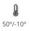
• HARDWARE FEATURES
The Cross Plus Twonav GPS interface is made up of 6 buttons, 4 side buttons and 2 on the touch screen. The built-in lithium-ion battery guarantees 20 hours of autonomy.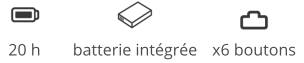
• CARTOGRAPHY
- Download routes from connected providers: IGNRando, TraceGPS, LaTrace, Utagawa VTT, FFCT
- Navigation on configured routes, followed by a set of waypoints... (*.FIT, *.BTRK, *.GPX, *.KML, *.KMZ, *.PLT, *.RTE and *. TRK)
- Analysis of the course on computer
- Terrain relief highlighting: add shading to the map to more clearly show the elevation of the area being traveled
- The internal memory of the GPS allows you to store many types of maps
• REAL-TIME MONITORING AND SECURITY
With SeeMe™, broadcast your position in real time wherever you are. And in the event of an accident, send a distress message to those around you (predefined contact).
• APPLICATION SMARTPHONE TWONAV LINK
Download the TwoNav Link application and pair it with your GPS via Bluetooth, so that your activity data is automatically downloaded and you can receive notifications, messages,...
• UN GPS CONNECTÉ
Upload your activities so they are stored and accessible wherever you are. Before setting off on an adventure, synchronize your GPS with the GO Cloud and download the route of the day.
Share your activities online with the most coveted tools: Strava™, TrainingPeaks™, Komoot™, Google Drive™, Dropbox™, ...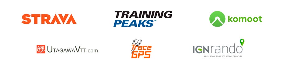
• THE LAND SOFTWARE
The GPS Cross Plus includes a one-year free subscription to LAND 9 software, prepare your routes with professional and intuitive software.
A multitude of functions:
- Overlay of several maps
- 3D map display
- Unlimited creation of waypoints, routes and tracks
- Download tracks and routes from online providers
- Advanced route editing
- Road navigation calculation
- Customizable profiles by sports disciplines
- Estimation of arrival times at destination
- Workouts over a certain duration, distance, heart rate and pace
- Workouts with Trackattack
- Estimation of calories burned
- Configurable alerts
- Automatic and manual laps
- Real-time altitude graph
- Customization of data pages
- Device button customization
- Retransmission and emergency message with SeeMe
- Compatibility with Geocaching and compatibility with e-Roadbooks
Other interesting features:
• Download free internet routes of the region you want to visit
• Mark waypoints in places you want to highlight
• Activate the deviation alarm to be notified when you deviate from your route
• Monitor 120 data fields in real time (altitude, slope, heading, coordinates, temperature....)
• Return to the starting point or calculate the shortest route home
• Mark waypoints on the map to highlight relevant locations
Included in this pack:
• All of France at 1:100,000th IGN preloaded on the internal memory
• OpenStreetMap (OSM) world map
• 3 years of SeeMe™ free
• QuickLock stem/handlebar bike mount (2 levels)
• USB type C cable for PC connection
• Application App TwoNav (Android/iOS)
• Application Link (Android/iOS)
• Personal space on the cloud GO TwoNav
• 1 year TwoNav PRO subscription plan
Mapping of additional choice:
• France Topo Full (IGN - Scale 1:25.000)
• France Topo 10 departments (IGN - Scale 1:25.000)
• France Topo Zone (IGN - Scale 1:25,000)
• France Aeronautics ICAO
• Spain Topo Full (IGN - Scale 1:25.000)
• Spain Topo Zone (IGN - Scale 1:25,000)
• Spain Topo Province (IGN - Scale 1:25.000)
• Germany Topo Full (IGN - Scale 1:25.000)
• Germany Topo Zone (IGN - Scale 1:25.000)
• Germany Topo Region (IGN - Scale 1:25.000)
• Switzerland Topo Full (IGN - Scale 1:25.000)
• Switzerland Topo Zone (IGN - Scale 1:25,000)
• Italy Fraternali (IGN - Scale 1:25.000)
Accessories available:
• Carrying case M
• Chest heart rate monitor belt
• Heart rate armband
• Magnetless cadence sensor
• QuickLock stem/handlebar bike mount
• Support QuickLock frontal
• Support QuickLock frontal guidon
• QuickLock bracket with RAM adapter
• QuickLock bike stem/handlebar mount
• Bike-level front QuickLock mount (diam.31.8mm)
• High bike front QuickLock support (diam.31.8mm)
• Bike-level front QuickLock mount (diam.35mm)
• High bike front QuickLock support (diam.35mm)
• Support QuickLock GoPro
• TwoNav Adjustable Lanyard
• TwoNav Elastic Lanyard
• TwoNav Retractable Lanyard
• QuickLock Carabiner Mount
• QuickLock backpack bracket
Reviews
Au top
Commande réceptionnée dans les délais annoncés et conforme. Au top, merci !
Quant au produit, il fonctionne très bien mais je n'en ai pas encore fait le tour tant les fonctionnalités sont riches et abondantes.
Service parfait
Comme d'habitude / très bien
très bien
Un gps pratique et très bien adapté à ma pratique du vtt et de la rando. Superbe écran de bonnes dimensions et lisible en toutes circonstances. Accès à beaucoup de cartes. Le logiciel twonav est pratique pour le traçage.
Prestation de mgaffaires parfaite
Très bien mais…
L’aspect général du GPS est qualitatif.
La taille de l’écran est parfaitement adaptée et de très bonne qualité.
Une fois maîtrisée la configuration du système est très complète et répond aux différentes pratiques proposées.
Par contre il est très sensible à la proximité des surfaces métalliques avec la perte du signal satellites. Le support fourni pour une fixation sur la potence ou le cintre est de facto inadapté. Ça oblige d’acquérir en plus un support déporté.
La prestation fournie par MGaffaires est irréprochable.
Accessories
IGN Top25 Map Reg...
109,90 €ANT+ TwoNav Heart...
39,00 €Bike mount for Qu...
19,00 €TwoNav QuickLock ...
29,00 €Magnetless TwoNav...
35,00 €TwoNav Heart Rate...
59,00 €TwoNav Bike Stem/...
19,00 €Support QuickLock...
29,00 €Support QuickLock...
29,00 €Support QuickLock...
29,00 €Adjustable TwoNav...
4,50 €TwoNav GPS elasti...
7,50 €TwoNav GPS retrac...
19,00 €TwoNav GPS carabi...
24,00 €TwoNav GPS backpa...
34,00 €Cross TwoNav GPS ...
29,00 €TwoNav USB-USB C ...
7,00 €Land 10 Twonav so...
126,09 €