No products
Product successfully added to your shopping cart
There are 0 items in your cart. There is 1 item in your cart.


TwoNav Mountain Bike GPS
GPS Velo Mountain TwoNav - pack VTT avec ceinture cardio-fréquencemètre
The Velo Mountain TwoNav GPS has all the features for mountain biking.
Robust, light and compact, this version of the GPS comes with MTB topographic maps, a heart rate monitor and supports (stem and arms).
True connected GPS, share your activities with the new GO TwoNav platform or on Strava™.
• Topographic map for mountain biking
• 120 customizable data fields
• Size: 105 x 65 x 20mm - Weight: 110g
• Transflective touchscreen (3'')
• High resolution 240 x 400 pixels (sunlight readable)
• Battery: Li-Ion 1650mAh
• Internal memory: 12 GB space for data
• Connected GPS: ANT+/BLE sensors, Bluetooth, GPRS, Wi-Fi
• 3D electronic compass
• Altimetric barometer
• PC connection: MicroUSB
• Shock, water, dust and mud resistant: IP67
• Supported temperatures: -10°C ~ 60°C
Free Velo TwoNav software and feature updates (wireless over Wi-Fi)
Color edging on the case: black, red or white
IGN cartography of your choice: 5 tiles, whole of France or 10 departments
Possibility to pay in 3 instalments, ask us at contact@mgaffaires.com

687 Items
In stock
- Write a review
- Remove this product from my favorite's list.
- Add this product to my list of favorites.
Data sheet
| Weight | 110 g |
| Dimension | 105 x 65 x 20 mm |
| Screen | Transflective Touch (3”) |
| Resolution | 240 x 400 pixels |
| Certificate | IP67 |
| Instruments | Compass, Barometer, Accelerometer... |
| GPS chip | SE 880 |
| Battery | Li-ion 1650mah |
| Autonomy | 10h (standard) |
| Internal flash memory | 16 GB (12 GB free for data) |
| Connection PC | MicroUSB |
More info
TwoNav Velo Mountain GPS - SPECIAL MTB PACK: topographic map and cardio belt
A GPS designed for all mountain biking disciplines
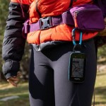
The Velo Mountain is a compact, light and robust GPS. Resistant to vibrations, water, dust and mud as well as extreme temperatures.
The high-resolution transflective touchscreen is readable in direct sunlight and the 4 buttons, 2 on the front and 2 on the sides, make it easy to use on the bike.
This model incorporates a topographic map for mountain biking and mapping features:
- Navigation on configured routes, followed by a set of waypoints... (*.BTRK, *.GPX, *.KML, *.KMZ, *.PLT, *.RTE and *.TRK)
- Analysis of the course on computer
- Terrain relief highlighting: add shading to the map to more clearly show the elevation of the area being traveled
- The internal memory of the GPS can store many types of maps (road maps, satellite maps, etc.)
Le GPS est fourni avec une ceinture cardio-fréquencemètre de dernière génération à technologie ANT+™/BLE (low energy). Avec le cardio-fréquencemètre, vous pourrez contrôler votre rythme cardiaque dans les pentes raides lors de vos sorties !
A GPS focused on performance and safety
120 data fields are available and fully customizable: distance, elevation, altitude, heart rate, speed, cadence…
Data for road biking and specific orientation tools for mountain biking are at your disposal.
Choose your discipline and the Velo adapts its configuration so that you get the most out of its features.
A multitude of functions:
- Custom button configuration
- Adjustable autonomy thanks to different modes of use
- Multi-map overlay and 3D display
- Unlimited creation of waypoints, routes and tracks
- Download tracks and routes from online providers
- Display of the altitude of your current position or that of a mountain pass on graphs
- Road navigation calculation
- Estimation of arrival times at destination
- Workouts with the Trackattack function
- Estimation of calories burned
- Configurable alerts
- Automatic and manual laps
- Real-time altitude graph
- Live broadcast
- Emergency messages
- Compatibility with geocoching and e-Roadbooks
- Data synchronization and backup on GO TwoNav cloud
The SeeMe tool allows you to transmit your position in real time to your running partners and the GPS offers the possibility of sending an email or a text message to those around you for remote tracking of your location.
CARD FORMATS
14 GB of free internal memory allows you to complete the basic map loaded in the device, many map formats are compatible: topographic, road, aerial photographs...
COMPATIBLE WITH ANT+™/BLE SENSORS
The GPS is compatible with TwoNav's own sensors (heart rate monitor belt, cadence and speed sensor), as well as with ANT+ technology sensors on the market.
A connected GPS
With the Bike GPS, nothing could be easier to share your data. Quickly connect via Wi-Fi to a tablet, smartphone or computer and upload your activities to the GO TwoNav cloud.
The TwoNav platform keeps your activities and all your data safe and allows you to share them with your friends (Strava™ compatibility).
Included in this pack:
• 5 free tiles from IGN France at 1:25,000 (depending on mapping option)
• Whole IGN France map in 1:25,000 format (depending on mapping option)
• 10 IGN departments in 1:25,000 format (depending on cartography option)
• All of France at 1:100,000th IGN preloaded on the internal memory
• OpenStreetMap (OSM) world map
• Heart rate belt
• 2 bike supports: attachment to the stem and on the arm
• SIM card
• 6 months free SeeMe™ service
• Mains wall charger
• USB cable for PC connection (USB-MicroUSB)
• Application "App TwoNav Premium" (Android/iOS)
• Land software (Windows/Mac) with 50% discount on the purchase of Land Premium software (full version)
• Personal space on the cloud GO TwoNav
Accessories available:
• Carrying case
• Mains charger
• emergency charger
• Speed u200bu200band cadence sensor
Reviews
Accessories
TwoNav GPS carryi...
29,00 €IGN Top25 Map Two...
39,90 €IGN Top25 Map Reg...
109,90 €IGN Top25 map of ...
239,92 €ANT+ TwoNav Heart...
39,00 €TwoNav speed/cade...
45,00 €TwoNav GPS Stylus
4,00 €Bike mount for Qu...
19,00 €TwoNav QuickLock ...
29,00 €TwoNav GPS Mains ...
29,00 €TwoNav Powerup AA...
26,00 €Adjustable TwoNav...
4,50 €TwoNav GPS elasti...
7,50 €TwoNav GPS retrac...
19,00 €TwoNav GPS carabi...
24,00 €TwoNav GPS backpa...
34,00 €TwoNav USB-MicroU...
7,00 €