No products
Product successfully added to your shopping cart
There are 0 items in your cart. There is 1 item in your cart.


GPS Terra TwoNav
GPS Terra Twonav - multisport, hiking, mountain biking...
Model to choose:
- Terra - Blue (32 GB)
- Terra - Blue (64 GB)
Cartographie IGN au choix (en plus de la carte Topo France 1:100000ème)
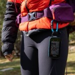
Terra is the ergonomic and very handy Twonav GPS designed for mountain lovers.
Multisport GPS, its characteristics distinguish it from other GPS, use it for both hiking and cycling (MTB, gravel, enduro, road).
Explore areas you don't know with a large 3.7 inch color touch screen, 3 front buttons, 4 side buttons and a speaker.
Visualize the entire route with precision with topographic, orthophoto, road and relief maps (IGN, SwissTopo, Alpina, Piolet, SUA, TomTom, OpenStreetMaps...).
• Size: 115 x 80 x 19mm - Weight: 198g
• 3.7" Blanview display with Optical Bonding and automatic backlight
• Capacitive multitouch GorillaGlass touch screen for use even with gloves
• High resolution 480 x 640 pixels (sunlight readable)
• Easy to use with 3 front and 4 side buttons
• Smooth GPS for quick interaction
• Military certification MIL-STD-810 (resistant to shocks, rain and extreme temperatures)
• Topographic map and OpenStreetMap world map (OSM)
• 120 customizable data fields
• Compass with automatic calibration for more precise guidance
• Built-in battery: Li-Ion 2600 mAh
• 32 GB internal memory: 28 GB of space for data (add your own maps)
• Connected GPS: Dual ANT+/BLE sensors, Wi-Fi (2.4 Ghz / 5 Ghz)
• Loud speaker
• 3D electronic compass
• Altimetric barometer
• PC Connection: USB-C
• Robust, resistant to shocks, water, dust and mud: IP67
• Supported temperatures: -10°C ~ 50°C
Many supports available: bike supports, transport cover, straps, backpack clip
Wireless software and feature updates over Wi-Fi
IGN cartography of your choice: whole France or 10 departments, Spain, Germany, Switzerland, Italy, aeronautical France, Great Britain, Austria
Land 10 software license (tool to plan your routes, analyze your data ...)
Possibility to pay in 3 instalments, ask us at contact@mgaffaires.com

35979 Items
In stock
- Remove this product from my favorite's list.
- Add this product to my list of favorites.
Data sheet
| Weight | 198 g |
| Dimension | 115 x 80 x 19 mm |
| Screen | Touch, color / 3.7” Blanview with Optical Bonding and automatic backlight |
| Resolution | 480 x 640 pixels |
| Certificate | IP67 / MIL-STD-81 |
| Instruments | Compass, Barometer, Accelerometer, Speaker, Tricolor LED |
| Battery | Li-Ion 2600 mAh |
| Autonomy | 15h (standard) |
| Internal flash memory | 32 GB of which 28 GB available for data |
| Connection PC | USB-C |
| Manufacturer reference | V1091B |
More info
Terra Twonav GPS Highlights:
- 4 navigation networks (GPS+Galileo+Glonass+Beidou) with the new, more efficient UBlox GPS chip, geolocation is faster
- New SBAS EGNOS satellite augmentation system for wider coverage and higher accuracy
- Multi-band (2.4 Ghz / 5 Ghz) 5G Wi-Fi technology for fast file transfers
- Dual Bluetooth for simultaneous use of sensors and smartphone connection
• INTERFACE / NAVIGATION
Easily track every section of your activity with a large, heavy-duty 3.7" touchscreen featuring Gorilla Glass technology. Work comfortably with maps thanks to a wide view.
Visualize small details with precision thanks to a simple and intuitive interface.
GPS Terra complies with the MIL-STD-810G standard which is the most demanding for equipment dedicated to the outdoors. It is designed to be used in difficult environmental conditions: altitude, rain, humidity, freezing, thawing, dust, mud...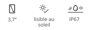
Explore your environment and choose the type of navigation that suits you best:
- free browsing
- navigation by following a track
- navigation by entering specific coordinates
- compass navigation
Create waypoints on your route and add information to your route.
• HARDWARE FEATURES
The Terra GPS interface consists of 7 buttons, 3 front buttons and 4 side buttons.
Enjoy a long battery life of 15 hours for long distance activities or a weekend activity.
•TECHNOLOGY
Terra GPS incorporates more powerful chips with multi-band Wi-Fi (2.4Ghz / 5Ghz) for fast file transfers.
The 4 navigation networks (GPS + Galileo + Glonass + Beidou) allow fast and precise positioning.
The SBAS/EGNOS (European Geostationary Navigation Overlay Service) satellite augmentation system allows for wider coverage and greater accuracy in geolocation.
Connect sensors like a heart rate monitor and receive notifications simultaneously with Bluetooth Dual technology.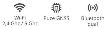
• REAL-TIME MONITORING AND SECURITY
Explore further without compromising your security. Be locatable at all times thanks to SeeMe™.
In the event of an accident, send emergency alerts to your family or friends.
Wherever you are, the SeeMe™ service broadcasts your location in real time.
• SYNCHRONIZATION WITH THE CLOUD
The Terra Twonav GPS automatically syncs your new activities and saves them to your secure GO Cloud personal space.
You can connect to online route providers (Komoot, Trace GPS, UtagawaVTT...) to find a selection of the best routes.
Share your outings with your friends on social networks: Strava, Komoot, Facebook, Twitter...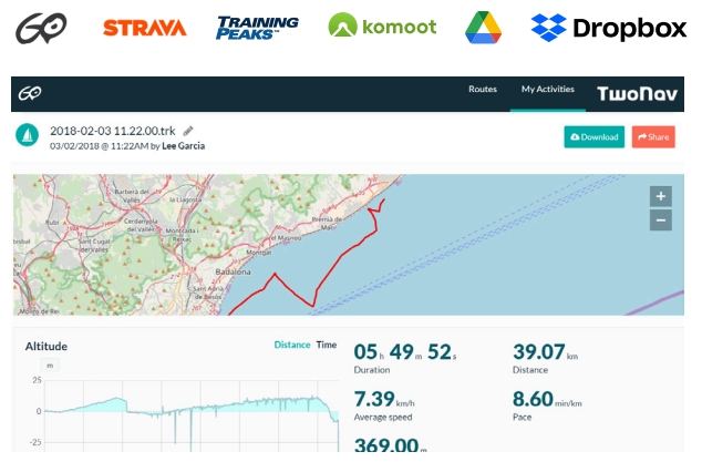
A GPS designed for hiking and all cycling disciplines (MTB, road, downhill)
The Terra TwoNav is a GPS that has been designed for outdoor and mountain activities: hiking, biking, paragliding...
The Terra GPS comes with 2 bike mounts, place the GPS on the stem or on the handlebars as you see fit.
Its interface with a large 3.7-inch screen and seven buttons allows you to take full advantage of the GPS.
The buttons make it possible to use the GPS even with gloves or in difficult environments.
This template incorporates a topographic map and mapping features
- Voice prompts for direction tracking
- Navigation on configured routes, followed by a set of waypoints... (*.BTRK, *.GPX, *.KML, *.KMZ, *.PLT, *.RTE and *.TRK)
- Analysis of the course on computer
- Terrain relief highlighting: add shading to the map to more clearly show the elevation of the area being traveled
- The internal memory of the GPS can store many types of maps (road maps, satellite maps, etc.)
A large amount of data and functions
120 data fields are available and fully customizable: distance, elevation, altitude, heart rate, speed, cadence…
Data for road cycling and specific orientation tools for mountain biking are at your disposal.
Choose your discipline and adapt the configuration of the GPS to suit it so that you get the most out of its features.
A multitude of functions:
- Custom button configuration
- Adjustable autonomy thanks to different modes of use
- Multi-map overlay and 3D display
- Unlimited creation of waypoints, routes and tracks
- Download tracks and routes from online providers
- Display of the altitude of your current position or that of a mountain pass on graphs
- Road navigation calculation
- Estimation of arrival times at destination
- Workouts with the Trackattack function
- Estimation of calories burned
- Configurable alerts
- Automatic and manual laps
- Real-time altitude graph
- Live broadcast
- Emergency messages
- Compatibility with geocoching and e-Roadbooks
- Data synchronization and backup on GO TwoNav cloud
Other interesting features:
• Preview a route and locate the most important points before exiting
• Follow step-by-step instructions with a voice speaker
• Create waypoints of places you want to highlight
• Return to the starting point or calculate the shortest route home
• Mark waypoints on the map to highlight relevant locations
• Access 120 real-time data fields (altitude, slope, heading, coordinates, temperature....)
• Connect a BLE sensor to get real-time data
Included in this pack:
• 3 years of SeeMe™ free
• All of France at 1:100,000th IGN preloaded on internal memory
• OpenStreetMap (OSM) world map
• TomTom™ road map - your country
• QuickLock stem/handlebar bike mount (2 levels)
• USB cable for PC connection (USB-C)
• Application App TwoNav (Android/iOS)
• Application Link (Android/iOS)
• Personal space on the cloud GO TwoNav
• 1 year TwoNav PRO Subscription Plan TwoNav App (Android/iOS)
Cartography of your choice
• France Topo Full (IGN - Scale 1:25.000)
• France Topo 10 departments (IGN - Scale 1:25.000)
• France Topo Zone (IGN - Scale 1:25,000)
• France Aeronautics ICAO
• Spain Topo Full (IGN - Scale 1:25.000)
• Spain Topo Zone (IGN - Scale 1:25,000)
• Spain Topo Province (IGN - Scale 1:25.000)
• Germany Topo Full (IGN - Scale 1:25.000)
• Germany Topo Zone (IGN - Scale 1:25.000)
• Germany Topo Region (IGN - Scale 1:25.000)
• Switzerland Topo Full (IGN - Scale 1:25.000)
• Switzerland Topo Zone (IGN - Scale 1:25,000)
• Italy Fraternali (IGN - Scale 1:25.000)
Accessories available:
• RAM car suction cup mount
• RAM mount for motorcycle/quad handlebars
• Car RAM Holder
• Heart rate belt
• Magnetless cadence sensor
• QuickLock bike stem mount
• Quicklock bike front mount
• Cover L
• Cradle (without QuickLock)
• RAM support for motorcycle/quad handlebars
• RAM mount for bicycle handlebars
• 2A microUSB mains charger
• Cradle (with QuickLock) + QuickLock bike stem support
• Heart rate sensor armband
• QuickLock bike stem/handlebar mount
• Bike-level front QuickLock mount (diam.31.8mm)
• High bike front QuickLock support (diam.31.8mm)
• Support QuickLock GoPro
• QuickLock RAM adapter bracket
• Bike-level front QuickLock mount (diam.35mm)
• High bike front QuickLock support (diam.35mm)
• TwoNav Adjustable Lanyard
• TwoNav Elastic Lanyard
• TwoNav Retractable Lanyard
• QuickLock Carabiner Mount
• QuickLock backpack bracket
Reviews
Terra en remplacement du Cross
Transfert des cartes sans problème avec mon ancien gps, très content de celui ci avec son grand écran par rapport au Cross me donnant une vision d'ensemble bien meilleure. Coté achat bon prix et livraison rapide, parfait
Gros progrés sur le positionnement - trés bon GPS
Le positionnement initial - très (trop) long sur mon précédent GPS (CROSS 2020) est maintenant rapide et le tracé est précis. Possibilité de mettre IGN France entière + divers autres cartes sur le 64 Go... donc très satisfait de ce nouveau modèle. MGAFFAIRES disponible et très réactif pour des renseignements. Prix attractif et plus de souplesse de livraison, donc je conseille.
Remplace mon Trail 2
Acheté car mon Trail 2 était en panne de charge. Le Terra fait la localisation beaucoup plus vite et avec précision. J'en suis à mon 3ème Twonav car je maîtrise la création des cartes et la navigation. J'adore, je m'en sers pour randonner pas pour le VTT (J'ai Garmin pour le vélo de route). Bel écran ,très facile à manipuler d'une main avec les boutons, batterie durable sur mes sorties "normales". J'ai déjà Land et autres logiciels en complément (MOBAC, QMShack etc ..)
Le Terra après l'Anima+
Bon produit.
Peu utilisé encore mais idem a l'anima+ avec le wifi en plus pour charger les cartes et parcours. Au top.
Côté vendeur, au top aussi. Je me fourni beaucoup chez MG Affaires.
Encore merci pour la livraison sur Grenoble.
GPS Terra Twonav
Plus précis que le GPS intégré au Smartphone, grand écran très appréciable et utilisable quelles que soient les conditions météo. Satisfait de cet achat
GPS Terra TwoNav (Sans carte IGN)
GPS d'excellente facture. Écran très grand ce qui bonne une bonne lecture des cartes, visibilité sous le soleil excellente!
Prise en main rapide, le logiciel est convivial.
Produit design et fabriqué en Europe (Espagne) un petit plus!
Accessories
IGN Top25 Map Two...
39,90 €IGN Top25 Map Reg...
109,90 €IGN Top25 map of ...
239,92 €ANT+ TwoNav Heart...
39,00 €Bike mount for Qu...
19,00 €TwoNav QuickLock ...
29,00 €TwoNav GPS Mains ...
29,00 €TwoNav Trail/Aven...
29,90 €TwoNav Trail/Aven...
29,00 €GPS Trail/Aventur...
33,00 €RAM-Mount Bracket...
99,00 €TwoNav Trail/Aven...
69,00 €TwoNav Trail/Aven...
52,00 €QuickLock TwoNav ...
49,00 €Magnetless TwoNav...
35,00 €TwoNav Heart Rate...
59,00 €TwoNav Bike Stem/...
19,00 €Support QuickLock...
29,00 €TwoNav Raised Qui...
29,00 €Support QuickLock...
29,00 €Support QuickLock...
29,00 €Adjustable TwoNav...
4,50 €TwoNav GPS elasti...
7,50 €TwoNav GPS retrac...
19,00 €TwoNav GPS carabi...
24,00 €TwoNav GPS backpa...
34,00 €TwoNav USB-USB C ...
7,00 €