No products
Product successfully added to your shopping cart
There are 0 items in your cart. There is 1 item in your cart.


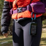
GPS Trail 2 Plus TwoNav
GPS Trail 2 Plus Twonav - hiking, cycling, mountain biking, outdoor sports...
IGN cartography of your choice (in addition to the Topo France 1:100000 map)
On foot or by bike, take advantage of the Trail 2 Plus Twonav, a GPS with a large capacitive touch screen equipped with the latest technologies.
New in GPS Trail 2 Plus:
• 4 navigation networks (GPS+Galileo+Glonass+Beidou) with the new, more powerful UBlox GPS chip, geolocation is faster
• New SBAS EGNOS satellite augmentation system for wider coverage and higher accuracy
• Multi-band Wi-Fi technology (2.4 Ghz / 5 Ghz) for fast file transfers
• Dual Bluetooth for simultaneous use of sensors and smartphone connection
• Tom-Tom France map in addition to OSM Europe
Technical specifications:
• Size: 131 x 80 x 20mm - Weight: 220g
• 3.7" Blanview display with Optical Bonding and automatic backlight
• Capacitive multitouch GorillaGlass touch screen for use even with gloves
• High resolution 480 x 640 pixels (sunlight readable)
• Easy to use with 4 front and 2 side buttons
• Smooth GPS for quick interaction
• Military certification MIL-STD-810 (resistant to shocks, rain and extreme temperatures)
• Topographic map and OpenStreetMap world map (OSM)
• 120 customizable data fields
• Compass with automatic calibration for more precise guidance
• Built-in battery: Li-Ion 4000mAh
• 32 GB internal memory: 28 GB of space for data (add your own maps)
• Connected GPS: Dual ANT+/BLE sensors, Wi-Fi (2.4 Ghz / 5 Ghz)
• Loud speaker
• 3D electronic compass
• Altimetric barometer
• PC connection: MicroUSB
• Robust, resistant to shocks, water, dust and mud: IP67
• Supported temperatures: -10°C ~ 50°C
Many supports available: bike supports, transport cover, straps, backpack clip
Wireless software and feature updates over Wi-Fi
Cartographie IGN au choix: 5 dalles, France entière ou 10 départements, Espagne, Allemagne, Suisse
Possibility to pay in 3 instalments, ask us at contact@mgaffaires.com

4192 Items
In stock
- Write a review
- Remove this product from my favorite's list.
- Add this product to my list of favorites.
Data sheet
| Weight | 215 g |
| Dimension | 130 x 80 x 20 mm |
| Screen | Transflective Touch (3.7”) |
| Resolution | 480 x 640 pixels |
| Certificate | IP67 |
| Instruments | Compass, Barometer, Accelerometer... |
| GPS chip | GPS + Galileo + Glonass + Beidou |
| Battery | Li-Ion 4000 mAh |
| Autonomy | 20h (standard) |
| Internal flash memory | 32 GB of which 28 GB available for data |
| Connection PC | MicroUSB |
| Manufacturer reference | V1063B |
More info
The key points of the GPS Trail 2 Plus Twonav:
• INTERFACE
Easily track every section of your activity with a large, heavy-duty 3.7" touchscreen featuring Gorilla Glass technology.
Visualize small details with precision thanks to a simple and intuitive interface.
The Trail 2 Plus GPS complies with the MIL-STD-810G standard, which is the most demanding for outdoor equipment. It is designed to be used in difficult environmental conditions: altitude, rain, humidity, freezing, thawing, dust, mud...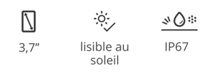
• HARDWARE FEATURES
The GPS Trail 2 Plus interface consists of 6 buttons, 4 front buttons and 2 side buttons.
Enjoy a long battery life of 20 hours for long distance activities.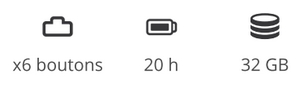
•TECHNOLOGY
The GPS Trail 2 Plus incorporates more powerful chips with multi-band Wi-Fi (2.4 Ghz / 5 Ghz) for fast file transfers.
The 4 navigation networks (GPS + Galileo + Glonass + Beidou) allow fast and precise positioning.
The SBAS/EGNOS (European Geostationary Navigation Overlay Service) satellite augmentation system allows for wider coverage and greater accuracy in geolocation.
Connect sensors like a heart rate monitor and receive notifications simultaneously with Bluetooth Dual technology.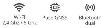
• REAL-TIME MONITORING AND SECURITY
Explore further without compromising your security. Be locatable at all times thanks to SeeMe™.
In the event of an accident, send emergency alerts to your family or friends.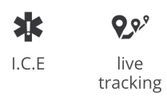
• SYNCHRONIZATION WITH THE CLOUD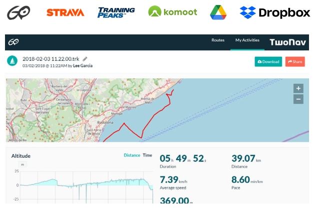
A GPS designed for hiking and all cycling disciplines (MTB, road, downhill)
The Trail 2 Plus TwoNav is a GPS that has been designed for outdoor and mountain activities: hiking, biking, paragliding...
Its interface with a large 3.7-inch screen and six buttons allows you to take full advantage of the GPS.
The buttons make it possible to use the GPS even with gloves or in difficult environments.
This template incorporates a topographic map and mapping features
- Voice prompts for direction tracking
- Navigation on configured routes, followed by a set of waypoints... (*.BTRK, *.GPX, *.KML, *.KMZ, *.PLT, *.RTE and *.TRK)
- Analysis of the course on computer
- Terrain relief highlighting: add shading to the map to more clearly show the elevation of the area being traveled
- The internal memory of the GPS can store many types of maps (road maps, satellite maps, etc.)
A large amount of data and functions
120 data fields are available and fully customizable: distance, elevation, altitude, heart rate, speed, cadence…
Data for road cycling and specific orientation tools for mountain biking are at your disposal.
Choose your discipline and adapt the configuration of the GPS to suit it so that you get the most out of its features.
A multitude of functions:
- Custom button configuration
- Adjustable autonomy thanks to different modes of use
- Multi-map overlay and 3D display
- Unlimited creation of waypoints, routes and tracks
- Download tracks and routes from online providers
- Display of the altitude of your current position or that of a mountain pass on graphs
- Road navigation calculation
- Estimation of arrival times at destination
- Workouts with the Trackattack function
- Estimation of calories burned
- Configurable alerts
- Automatic and manual laps
- Real-time altitude graph
- Live broadcast
- Emergency messages
- Compatibility with geocoching and e-Roadbooks
- Data synchronization and backup on GO TwoNav cloud
Other interesting features:
• Preview a route and locate the most important points before exiting
• Follow step-by-step instructions with a voice speaker
• Create waypoints of places you want to highlight
• Return to the starting point or calculate the shortest route home
• Mark waypoints on the map to highlight relevant locations
• Access 120 real-time data fields (altitude, slope, heading, coordinates, temperature....)
• Connect a BLE sensor to get real-time data
Included in this pack:
• All of France at 1:100,000th IGN preloaded on internal memory
• OpenStreetMap (OSM) world map
• TomTom™ road map - your country
• SIM card with 6 months of SeeMe™ free
• QuickLock stem/handlebar bike mount (2 levels)
• USB cable for PC connection (USB-MicroUSB)
• Application App TwoNav (Android/iOS)
• Application Link (Android/iOS)
• Personal space on the cloud GO TwoNav
Cartography of your choice
• France Topo Full (IGN - Scale 1:25.000)
• France Topo 10 departments (IGN - Scale 1:25.000)
• France Topo Zone (IGN - Scale 1:25,000)
• France Aeronautics ICAO
• Spain Topo Full (IGN - Scale 1:25.000)
• Spain Topo Zone (IGN - Scale 1:25,000)
• Spain Topo Province (IGN - Scale 1:25.000)
• Germany Topo Full (IGN - Scale 1:25.000)
• Germany Topo Zone (IGN - Scale 1:25.000)
• Germany Topo Region (IGN - Scale 1:25.000)
• Switzerland Topo Full (IGN - Scale 1:25.000)
• Switzerland Topo Zone (IGN - Scale 1:25,000)
• Italy Fraternali (IGN - Scale 1:25.000)
Accessories available:
• RAM car suction cup mount
• RAM mount for motorcycle/quad handlebars
• Car RAM Holder
• Heart rate belt
• Magnetless cadence sensor
• QuickLock bike stem mount
• Quicklock bike front mount
• Cover L
• Cradle (without QuickLock)
• RAM support for motorcycle/quad handlebars
• RAM mount for bicycle handlebars
• 2A microUSB mains charger
• Cradle (with QuickLock) + QuickLock bike stem support
• Heart rate sensor armband
• QuickLock bike stem/handlebar mount
• Bike-level front QuickLock mount (diam.31.8mm)
• High bike front QuickLock support (diam.31.8mm)
• Support QuickLock GoPro
• QuickLock RAM adapter bracket
• Bike-level front QuickLock mount (diam.35mm)
• High bike front QuickLock support (diam.35mm)
• TwoNav Adjustable Lanyard
• TwoNav Elastic Lanyard
• TwoNav Retractable Lanyard
• QuickLock Carabiner Mount
• QuickLock backpack bracket
Reviews
Accessories
IGN Top25 Map Two...
39,90 €IGN Top25 Map Reg...
109,90 €IGN Top25 map of ...
239,92 €ANT+ TwoNav Heart...
39,00 €Bike mount for Qu...
19,00 €TwoNav QuickLock ...
29,00 €TwoNav GPS Mains ...
29,00 €TwoNav Trail/Aven...
29,90 €TwoNav Trail/Aven...
29,00 €GPS Trail/Aventur...
33,00 €RAM-Mount Bracket...
99,00 €TwoNav Trail/Aven...
69,00 €TwoNav Trail/Aven...
52,00 €QuickLock TwoNav ...
49,00 €Magnetless TwoNav...
35,00 €TwoNav Heart Rate...
59,00 €TwoNav Bike Stem/...
19,00 €Support QuickLock...
29,00 €TwoNav Raised Qui...
29,00 €Support QuickLock...
29,00 €Support QuickLock...
29,00 €Adjustable TwoNav...
4,50 €TwoNav GPS elasti...
7,50 €TwoNav GPS retrac...
19,00 €TwoNav GPS carabi...
24,00 €TwoNav GPS backpa...
34,00 €RAM TwoNav handle...
46,55 €QuickLock GPS Tra...
33,25 €TwoNav USB-MicroU...
7,00 €