No products
Product successfully added to your shopping cart
There are 0 items in your cart. There is 1 item in your cart.


GPSMAP 67 / GPSMAP 67i Garmin
GPS portable GPSMAP 67 / GPSMAP 67i Garmin
Model to choose:
- GPSMAP 67: GPS with multi-band technology and extended GNSS
- GPSMAP 67i: Handheld GPS with inReach® technology (satellite text communication via global Iridium network)
Hiker, explorer or operator, you will love the Garmin GPSMAP 67 series.
Portable and rugged GPS units that provide accurate geolocation with multi-band technology and GNSS (Global Navigation Satellite System) support.
The GPSMAP 67i incorporates inReach® technology.
Thanks to two-way messaging, communicate with your loved ones, post messages on social networks.
In an emergency, send an interactive SOS message to the search and rescue center (Garmin Response), available 24/7.
• Multi-GNSS and Multi-band GPS technology for even more precise geolocation in harsh environments
• Extended battery life: up to 180 hours in GPS mode [GPSMAP 67]
• Robust and resistant interface (IPX7)
• MIL-STD-810G certified for impact and temperature resistance (-20°C to +60°C)
• Lithium-ion battery powered
• 3-inch (3.5 cm diagonal) 65,000 color transflective display
• 240X400 pixel resolution
• Internal memory: 16 GB
• 32 GB microSD card slot (possibility to add topographic maps)
• inReach technology to stay in touch with your loved ones, the base camp when the network is non-existent [GPSMAP 77i]
• 3-axis tilt-compensated electronic compass
• Barometric altimeter
• Wireless features: Wi-Fi, Bluetooth, ANT+
• Create up to 250 routes / up to 10,000 waypoints
• Tracks: up to 20,000 points / up to 250 saved GPX tracks / up to 300 saved FIT activities
• Map Compatibility: City Navigator, Topographic Maps, BlueChart G2 Marine Charts, Custom Maps
• LiveTrack real-time tracking functionality
• TracBack function to return to the starting point
• BirdsEye Satellite Imagery service, download without subscription
• Equipped with a Led flashlight and an SOS beacon to signal its position
Option cartographie (carte microSD/SD):
- IGN TOPO FRANCE V7 PRO FRANCE AULS +DOM-TOM
-IGN TOPO FRANCE V7 Pro Region
- IGN Topo France v6 Pro Montagne (mountain trails of the Pyrenees, the Alps and Corsica)
Ideal for hiking, mountaineering, high mountains, treks, travel and expeditions
GPS for communities, workers and forestry operators
- delimitation of forests and plots,
- studies of topographic, hydrographic data, and identification of cutting areas
Possibility to pay in 3 instalments, ask us at contact@mgaffaires.com
GPS Garmin USA

6922 Items
In stock
- Remove this product from my favorite's list.
- Add this product to my list of favorites.
Data sheet
| Weight | 230 g [GPSMAP 67] / 241 g [GPSMAP 67i] |
| Dimension | 6,2 x 16,3 x 3,5 cm |
| Screen | 3.8 x 6.3 cm (7.6 cm diagonal - 3 inches) / transflective TFT color display, 65,000 colors |
| Resolution | 240 x 400 pixels |
| Certificate | IPX7 |
| Instruments | high sensitivity MULTI GNSS receiver (GALILEO/GPS/GLONASS), Multi-band (dual positioning frequencies), barometric altimeter, electronic compass |
| Battery | Lithium-ion |
| Internal flash memory | 16 Go |
| MicroSD card reader | yes / 32 GB (not included) |
| Connection PC | USB-C |
| Preloaded maps | Garmin TopoActive Europe |
| Waypoints | 10 000 |
| Routes | 250 |
| Tracking log | 20,000 points / 250 saved gpx tracks / 300 saved fitness activities |
More info

Principales fonctions / technologies:
MULTI-BAND GPS
Dual-frequency GPS provides unparalleled geolocation accuracy.
A constant recalculation of the position by the watch on the 2 frequencies of each GNSS network is carried out. Bad positioning data is eliminated.
GPS accuracy is highest in canyons, in cities and in harsh alpine environments.
SENSORS
- Barometric altimeter
- Compass
- Accelerometer
- Temperature sensor
The barometric altimeter allows you to accurately record the difference in altitude. It also indicates storm risks by analyzing barometric variations.
The 3-axis compass allows you to orient yourself regardless of the position of the GPS.
The accelerometer helps record movement for activity tracking.
PRELOADED TOPOGRAPHIC MAPS / SATELLITE IMAGERY
Preloaded TopoActive Europe maps show you peaks, parks, coasts, rivers, lakes and geographical points.
Download high-resolution satellite imagery directly to your GPSMAP 67 or GPSMAP 67i device over WiFi.
Easily find trails, choose camping and parking spots, and create
waypoints.
DESIGNED FOR ADVENTURE
The GPSMAP 67 and GPSMAP 67i are rugged, waterproof and designed to military standard MIL-STD-810G.
They are compatible with night vision goggles and incorporate an LED flashlight.
PAPERLESS GEOCACHING
The GPSMAP 67 series contains 250,000 geocaches from geocaching.com, the world's largest virtual geocache platform. No more manually entering coordinates, GPS supports geocaching GPX files to download geocaches and detailed data.
Also get automatic cache updates from Geocaching Live, including descriptions, histories, and hints.
ACTIVE WEATHER / DYNAMIC WEATHER
When connected to the Garmin Explore™ app, you can get real-time weather forecast information, so you don't get surprised by changing weather conditions.
Features of the GPSMAP 67i:
INTERACTIVE SOS ALERTS / EMERGENCY SITUATION
Send an interactive SOS to Garmin's IERCC, a 24/7 emergency response coordination center.
GLOBAL IRIDIUM SATELLITE NETWORK
The Garmin GPSMAP 67i allows you to communicate anywhere in the world with an Iridium subscription.
You can opt for an annual plan or a more flexible monthly plan.
BROWSING / SHARING
Leave without fear, the TracBack routing function brings you back to your starting point by retracing your route.
Share your location with those around you by sending your coordinates via message or directly to your MapShare™ web cartography.
Rest assured that your loved ones know exactly where you are!
On the GPSMAP 67i, they will be able to see your progress or ping your device to find out
your GPS position even if you are in a white zone.
INREACH WEATHER FORECAST SERVICE
Check the weather forecast for your location or a future destination.
Applications:
- GARMIN EXPLORE™ APP
Synchronize and share your hikes from anywhere!
This all-in-one app is designed for off-grid adventurers and outdoor enthusiasts. Download it to your smartphone to plan, navigate and review your activity.
- GARMIN MESSENGER™ APP
Never lose touch with your loved ones and friends.
Download the Garmin Messenger app to your smartphone, then pair it with your inReach® device for quick and easy messaging that's not limited to cell phone coverage areas.
Autonomy:
GPSMAP 67
- Tracking mode (default): up to 180 hours (> 7 days)
- Expedition mode: up to 840 hours
GPSMAP 67i
- GPS mode: up to 180 hours (> 7 days)
- GPS + inReach® mode activated and tracked every 10 minutes: up to 165 hours (> 6 days)
- Expedition mode + inReach® enabled: up to 425 hours (> 17 days)
Includedin the package:
- GPSMAP 67 / GPSMAP 67i (optional version)
- Garmin Topo Europe map (preloaded)
- Access to BirdsEye Satellite Imagery (directly on device without subscription)
- Charging/Data Charging Cable (USB-A to USB-C)
- Carabiner with clip
- Documentation
Manufacturer references:
- GPSMAP 67: 010-02813-01
- GPSMAP 67i: 010-02812-01
Comparison of Garmin GPSMAPs: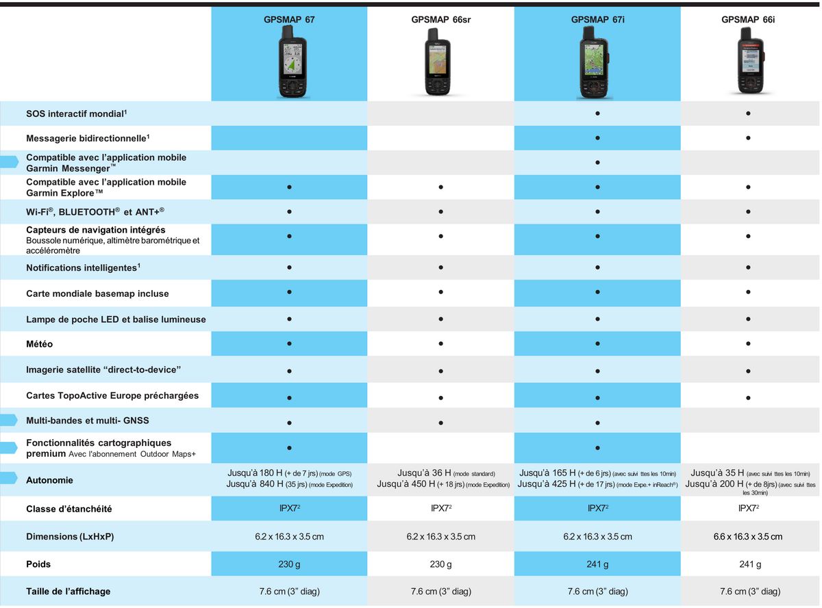
Reviews
GPSMAP 67
Je suis satisfait en tous points : l'accueil téléphonique, le site est très accessible pour trouver son produit et la livraison dans les temps. Le GPS choisi est remarquable après plusieurs semaines d'utilisation. Je recommande cette enseigne. Encore merci pour tous vos conseils. Bien cordialement,
bon matériel et bon prix
achat du Garmin GPSMAP 67 pour sa précision, ses extension mémoires, plein de fonctionnalités dans un volume réduit et une antenne de bonne qualité. Rapidement envoyé et reçu. Les premiers tests démontrent son efficacité. Bon prix, vendeur à recommander.
Gpsmap 67
Dès la commande réalisée, expédiée et livrée très rapidement. Super.
Je suis également très satisfait du prix de cet appareil sur le site MGaffaires, je n'ai pas trouvé mieux.
Merci pour votre service.
GPSMAP 67
Commande et livraison en 10 jours, un peu plus qu'annoncé sur le site.
Modèle à boutons un peu difficile à appréhender après 10 années sur un Oregon 600 à écran tactile. Documentation Garmin un peu léger pour tout maitriser.
En tous points, parfait !
Site bien conçu, conseils judicieux, commande aisée, délais respectés, emballage soigné, tout OK. Du vrai professionnalisme.
garmin 67i
Réponse rapide et de bon conseil ,prix inférieur à la concurrence et délais de livraison respecté malgré les grèves ,bravo et merci ????????
GPSMAP 67
Commande réalisée et livrée très rapidement.
Je suis très satisfait.
Merci
Appareil de bonne facture et site de vente agreable
Site parfait, bons échanges téléphoniques avec le vendeur, livraison dans les délais.
Pour l'appareil semble être de bonne qualité, à voir dans le temps,
achat d'un Garmin GPSMAP67
Je suis satisfait par l'accueil au téléphone, les explications et les services rendus. très bon GPS et très intuitif. La carte Garmin France entière V6, sur Micro SD est aussi de bonne qualité. Un site à recommander.
Super service
Réponses rapide, de très bons conseils, super produit et super conditions de vente.
Je recommande ! :)
excellent service
livraison impeccable dans les délais prévus.
Conseils techniques sur le produit au top
Meilleure conditions trouvées en vente en ligne.
GPSMAP 67
Le service est tres réactif et de bon conseil. Livré rapidement et produit conforme à mon attente.
Le marquage des waypoints a perdu de son intuitivité selon mes souvenirs de modèles plus anciens et parfois le curseur fait décaler le marquage de position.
Gps map 67i
Très satisfait de l’ensemble de votre prestation: commandé et livraison. Premiers tests du gps map très concluants. Réactivité et performances très améliorées par rapport au modèle précédent, gps 66.
Accessories
Garmin watch/GPS ...
25,00 €Garmin cadence an...
62,99 €Garmin NiMH Recha...
29,99 €Garmin GPS car kit
49,99 €Holder with Garmi...
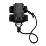
9,99 €Garmin GPS backpa...
19,99 €Garmin GPS neck s...
24,99 €Garmin GPS outdoo...
19,99 €Garmin GPS bike m...
11,99 €Garmin GPS Marine...
29,99 €Garmin textile he...
60,00 €Garmin GPS micro ...
11,99 €Garmin car charger
35,99 €Garmin GPSMAP 66s...
8,99 €Garmin GPS cord
12,99 €Mains charger + G...
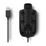
29,99 €Support with powe...
49,99 €Garmin GPSMAP 66i...
89,99 €Garmin GPS carryi...
19,99 €Garmin GPS car ch...
29,99 €Garmin GPS Cart M...
19,99 €Garmin Deluxe Bag
26,99 €Garmin GPS suctio...
75,99 €Garmin USB Type C...
14,99 €